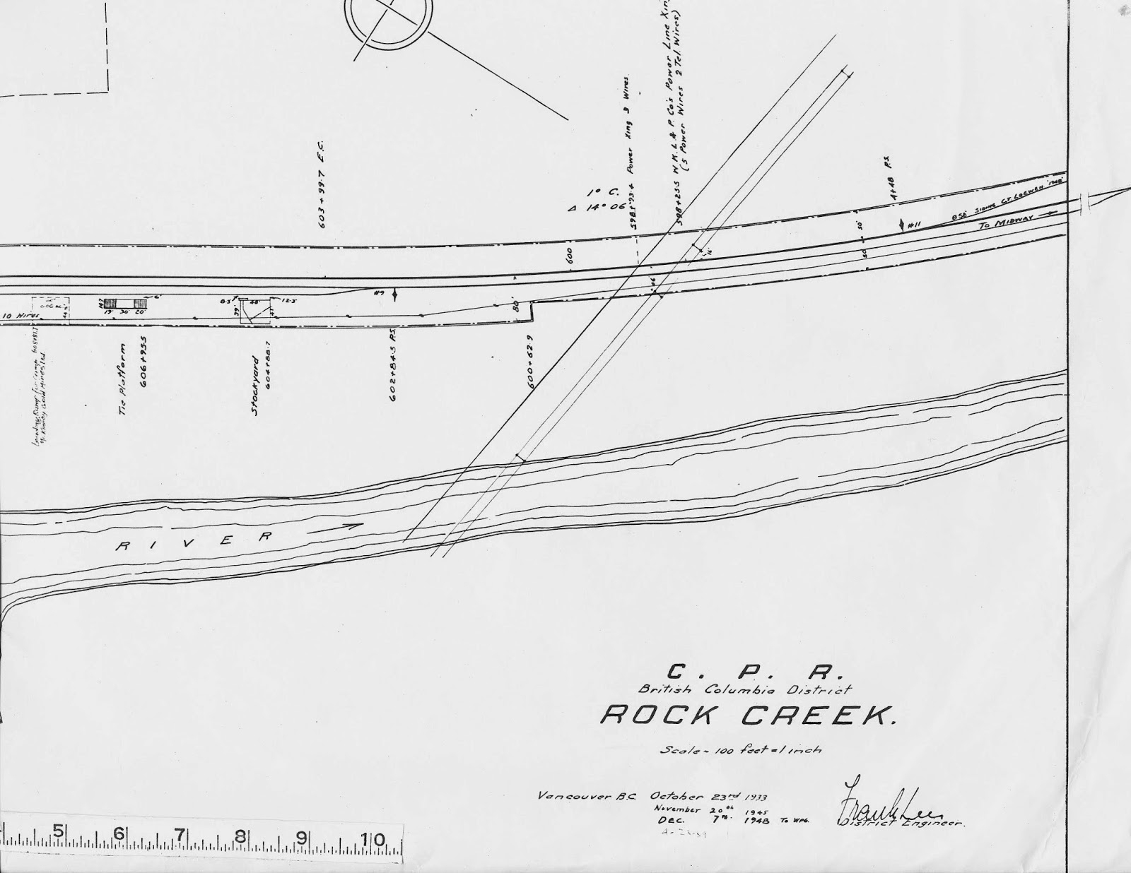
Below we show three parts of the original drawing: the East, centre and West sections of the station area. The drawing itself is quite large and the rule at the bottom of the pages is a condensed inch rule as these drawings were originally drafted in a scale of 1":100'. When they were copied for us by the CPR engineering department, they had already been condensed when transferred into microfiche format so I made sure to include the scale when photocopying and reducing them for scanning purposes. The scale was outside the border and had to be cut and pasted to the plan.
East End with Title Block.
Things to note: Drawing originally dated Oct 23, 1933 and updated in 1945, and 1948. A faint hand shows a date of April 23, 1959 which may be the time that the name of the Imperial Oil dealer was added near to the Standard Oil Co. name, its predecessor. On the far left and in this more recent hand is a label reading "Ramp for Camp McKinney Gold Mines Ltd." although no dimensions or footprint are given for the ramp - only a property lease demarcation of 60' x 44.5'. At extreme right a private siding is drawn in having been installed for "C T Loewen" dated 1948. This is likely the Cooke Lumber Company that Joe Smuin mentions in his book at Mileage 11.2. There are several buildings that are standing today: notably the sawmill building and beehive burner as well as other outbuildings. These are all plainly visible on Google Earth including a street view of the mill area. Our photos date from June, 2013.
Mill Building
Burner

 Saw-filer/Garage/Maintenance Building?
Centre Section.

Here we see the Station building drawn in with a cinder platform. This appears to be the original building that Smuin describes as hosting an agent-operator until 1931 or so in addition to serving the public. The photo in his book reveals a replacement structure that was erected in 1961. There is a another good photo of it taken in 1964 by Stan Styles - which includes the section foreman's house - published by GTC Collectibles: CPR-ROCKCR-1.
Here is a photo dated 1915, of the original station from the Okanagan Archive Trust Society: http://www.oldphotos.ca/archivos/record.php?collectionID=2&recordID=506158074

This station measures 16.4' x 36.3'. The cinder platform measures 14' x 64' and is set back 8 feet from the centreline of the track. Note the telephone drop for the agent to the station. The Section House and its outbuildings (including a pump-house) are surrounded by a fence as is the whole of the railway right-of-way, this being denoted by the dashed and dotted lines. The fuel and gas tanks for the Bulk oil dealer would have been located inside the berm that is drawn in the lower left corner of the fenced-in quadrangle. Not sure what the platform and shed represent but would guess that they were part of the oil dealer buildings. Inside the compound are indecipherable lines and numbers. To the right is a Stockyard on the CPR property and to the left is what appears to be another Stock-pen with a scale, this time outside the CPR property. The ubiquitous Tie Loading Platform is pictured with ramps at each end. One day we will provide some detail on platforms and ramps in general.
West End.
In this section are the small buildings characteristic of many CPR sidings: tool shed, privy, bunkhouse, and some small sheds near the road. Note the cross-bucks (X-ing sig.) and cattle guards (C G) drawn in at the public road crossing on the West end. There is a "Private Crossing" close to the station (no cross-bucks here - just a warning sign) and houses drawn outside the CPR boundaries. At the bottom is the road bridge to the village. The siding itself has # 11 switches while the double ended back track has # 9's. The sawmill spur takes off from the mainline with a # 11 switch. On one or two station ground plans in my collection, I note that # 9 switches were being upgraded to # 11's on the mainline. I believe this occurred in the 1950's. Of course we modelers cannot usually replicate this as we are constantly dealing with space constraints and sharp curves. In my case, I have adopted a # 7 standard for the switches on my layout as has a fellow "Kettle-ite". And of course, we have the CPR drawings for a prototype # 7 switch. We built many by the old one-off method but a few years ago we acquired the Fast Tracks jigs which are superb accessories that we highly recommend.

We should note that one mile to the South (railway East) at mileage 10.2 was a log-loading spur for Oliver Sawmills - 664 feet long according to Smuin. Eventually, we will treat in detail of the railway service to the logging industry. Again, this KVR station could make an interesting and enjoyable scene on a layout with a fair amount of switching variety: stock cars, gondolas for ties, tank cars, ore cars, flats or box cars for lumber and with the log spur to the south, a string of log flats.
Coquihalla Man


No comments:
Post a Comment